Navigation systems are the lifeblood of aviation, guiding aircraft safely through the skies with precision and accuracy. In the world of aviation, various navigation aids and systems exist to ensure the seamless movement of aircraft. Among these systems, the VORTAC stands as a cornerstone of both civil and military aviation.
In this post, we’ll delve into the essential role of navigation aids and focus on VORTAC, exploring what it is and why it’s of paramount importance in aviation.

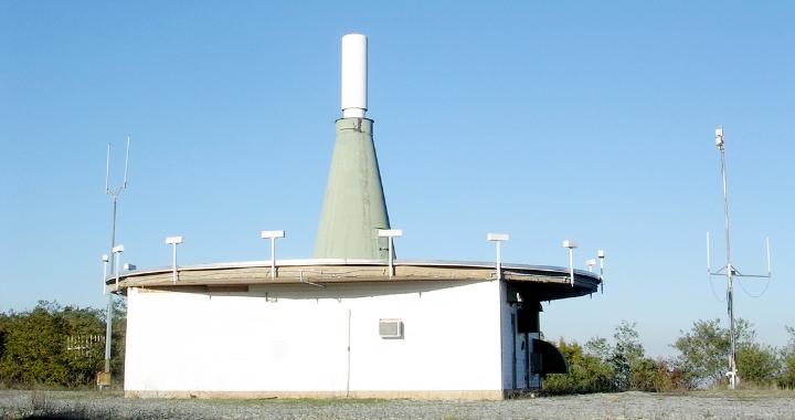
What Is A VORTAC In Aviation?
A VORTAC, short for “VHF Omnidirectional Range Tactical Air Navigation,” is a pivotal navigation system used extensively in aviation. This amalgamation of VOR (Very High Frequency Omnidirectional Range) and TACAN (Tactical Air Navigation) capabilities serves as a multifunctional beacon for aircraft.
VOR is primarily used for air navigation, aiding pilots in maintaining accurate course headings and staying on predefined airways. These airways are the highways in the sky, connecting airports and navigation points, allowing for safe and efficient travel.
VOR provides azimuth information, helping aircraft determine their radial or bearing from the station, whereas TACAN not only offers azimuth but also distance-measuring capabilities. Together, they create a powerful navigation tool that enables precise and reliable aircraft navigation. VORTAC stations are strategically located on the ground, functioning as vital waypoints in the sky, facilitating the safe and efficient movement of both civil and military aircraft.
What Is VOR?
VOR, which stands for “Very High-Frequency Omnidirectional Range,” is a fundamental component of the VORTAC system and plays a critical role in aviation navigation. It is a ground-based radio navigation system used by both civil and military aircraft to determine their azimuth or radial position relative to a VOR station.
A VOR station continuously transmits two radio signals: a reference signal and a variable signal. The reference signal radiates in all directions, while the variable signal rotates around the station like a lighthouse beacon. The aircraft’s receiver detects these VOR signals and measures the phase difference between them. This phase difference allows the aircraft to determine its radial position or bearing from the VOR station.
Most civil and military aircraft are equipped with VOR receivers. These receivers interpret the signals from VOR stations and display the radial or bearing information to the pilot. VOR is particularly valuable during instrument flight, providing a reliable means of navigating in poor visibility conditions or when flying in areas without visual references.
What Is TACAN?
TACAN, an acronym for “Tactical Air Navigation System,” is a critical navigation aid primarily used by military aircraft. While it shares some similarities with VOR, TACAN offers additional capabilities that make it indispensable for military aviation.
TACAN serves as a crucial tool in military aviation, providing accurate azimuth and distance-measuring information to guide aircraft during tactical operations. It is especially vital for military missions where precision is essential, such as combat situations, air refueling, and formation flying.
TACAN stations transmit two signals, just like VOR stations, but with some key differences. The first signal provides azimuth information, similar to VOR, helping aircraft determine their bearing from the TACAN station. The second signal, however, is unique to TACAN and is used for distance measurement. By measuring the time it takes for the aircraft’s TACAN receiver to receive the second signal, the system calculates the aircraft’s precise distance from the TACAN station. This combined azimuth and distance information is incredibly valuable for military aircraft to navigate accurately.
TACAN receivers are primarily found in military aircraft, helicopters, and some specialized civilian aircraft used in operations such as search and rescue. The system’s robustness and precision make it ideal for military missions requiring strategic positioning and coordination.

Does a VORTAC have DME?
Yes, a VORTAC typically includes Distance Measuring Equipment (DME). DME is an essential component of the VORTAC system, especially for civil aviation. DME stations transmit signals that enable aircraft to determine their precise distance from the station. When combined with VOR or TACAN azimuth information, DME provides pilots with accurate position data, helping them navigate with precision.

VORTAC Symbols
On aviation charts and maps, VORTACs are represented by specific symbols. These symbols indicate the presence of a VOR and TACAN station at the same location, along with the associated DME station. The symbol often consists of a small triangle with a dot inside it. This symbol serves as a quick reference for pilots and air traffic controllers when planning and executing flight routes.
In the United States, VORTAC frequencies are typically found in the radio range of 108.0 to 117.95 MHz, making them compatible with both VHF (Very High Frequency) and UHF (Ultra High Frequency) communication systems commonly used in civil and military aviation.

VORTAC is a crucial navigation system used in both civil and military aviation.
Understanding VORTAC and its symbols is essential for all those involved in aviation. It combines the capabilities of VOR and TACAN with DME. This allows pilots to navigate accurately and maintain safe separation between aircraft. It plays a significant role in enhancing safety management systems and ensuring the smooth operation of aircraft in the skies.
For more answers to questions related to your private jet ownership, consult our blog. And, if you’re looking for an easy and convenient tool that will help you and your crew avoid flight fatigue, explore our fleet of JetBeds to find the one that best fits your aircraft.